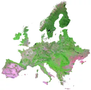
Remote sensing data is one of the largest sources of big data in the world, with an estimated 150 terabytes of new data generated every day, enabling seamless monitoring of ecosystems. In our research, we develop new remote sensing approaches to detect and understand changes in ecosystems in the wake of global climate and land use change. We focus intensively on forest ecosystems, with current emphasis on the quantification of disturbances (e.g. windthrow, bark beetle or fire) in Europe and the assessment of the recovery function after disturbances. Methodologically, our research is based on the evaluation of dense time series of optical satellite sensors, such as Landsat or Sentinel-2. To process the large number of individual images, we develop and use state-of-the-art approaches (so-called data cubes) on super-computers of the Leibniz Supercomputing Centre. Our remote sensing-based products are actively used to monitor changes in Europe's forests (LINK) and are used in a variety of research projects.
We use active laser scanning methods to create three-dimensional models of ecosystems. Terrestrial laser scanning enables the creation of highly detailed 3D models for local areas (e.g. a forest stand), while airborne laser scanning provides aerial data for landscape-level analyses. At our professorship we have access to a modern terrestrial laser scanner as well as a variety of existing airborne data sets. In our research, laser scanning plays an important role in the quantification of ecosystem structure (e.g. tree heights or gaps in the canopy), in the development of local geophysical models (e.g. for modeling local thermal characteristics), and in the large-scale analysis of biodiversity. As part of the global StrucNet network, we operate two long-term monitoring plots with permanent laser scanners, which provide continuous monitoring of canopy structural features in deciduous and coniferous forest systems.

One of the strengths of our research is the integration of remote sensing data with other spatial data (e.g. climatological reanalysis data) and existing models (e.g. Global Dynamic Vegetation Models). To this end, we cooperate with leading groups worldwide, but also develop our own approaches and methods. We use modern statistical methods (e.g. multi-level models, extreme value statistics) to quantify, explain and model changes in ecosystems. A particular focus is on gradual and abrupt changes in tree mortality and how these are related to climatic extremes (e.g. droughts and heat waves).

We have close ties to the topics of biodiversity and nature conservation and our research supports numerous research projects in these areas. Our data sets are used to create dynamic habitat models (e.g. for roe and red deer, lynx and chamois), to characterize habitats (e.g. historical disturbances) and life history traits (e.g. weight, horn growth), to spatially predict biodiversity and to select suitable sample areas. We work closely with the research department of the Berchtesgaden National Park, where we are actively involved in the collection and analysis of biodiversity data. Furthermore, part of our research focuses on the characterization of old and high conservation value forests in Europe, with earth observation playing a key role in their mapping. In particular, we investigate the influence of past disturbances on high conservation value forests and how disturbances can increase structural diversity.